

My Top 5 Hiking Trails in Beavers Bend State Park
Beavers Bend is a gem in southeastern Oklahoma on Broken Bow Lake. It is an exceptional park that covers 3,482 square miles and contains some exceptional hiking trails. Situated in the Kiamichi Mountains, a subrange of the Ouachita Range, the landscape of the park is rocky and heavily forested. With pines, oaks, cedars, and cypress trees, Beavers Bend is gorgeous in all seasons. Learn more about Beavers Bend by visiting TravelOK.com.
I have been visiting the area for the past eight years since it is only three hours from the Dallas area, and a couple years ago, my family bought a cabin in Hochatown. Since purchasing the cabin, I have spent so much time in Beavers Bend, and I have made so many memories on the trails in the park. See PinesandCoastlines.com for more information about Broken Bow and Beavers Bend to plan your trip. While there. hope you do one or more hikes. Here are my five favorite trails in state park - each trail will be linked to a map on AllTrails, an exceptional resource for hikers).
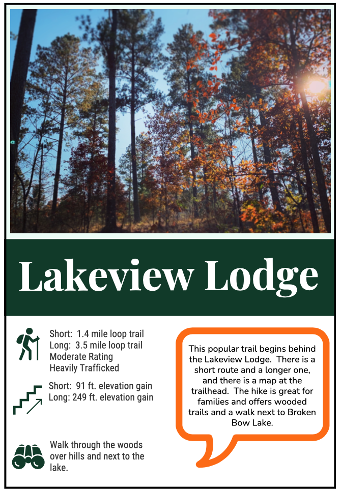
This trail is located outside of the most visited area of Beavers Bend State Park that is on Highway 259A, but it is easy to find from the main road (Highway 259) in Hochatown, you turn right on Stephen’s Gap Road and then make a left at the sign for the Lakeview Lodge (currently closed for renovations - January 2022). Park behind the lodge, and the trailhead will be to your left if you have your back to the lodge. There is a map with trail information at the beginning of the trailhead that will help you determine which part of the hike you will choose to do.
There is a shorter section and longer route for the Lakeview Lodge Trail, and although it is rated as moderate, the trail is less challenging than some of the others on this list. I like to start the loop going clockwise. This gives me views of the lake on the second half of the loop. This is a wonderful trail for wildlife watching and families. If you are looking for ways to make hiking more engaging for kids, I have another post you may enjoy. Click HERE to get ideas for hiking with young kids.
As with many hikes in Beavers Bend, leashed dogs are allowed on the hike, and if you want to extend your time on the trail, you can bring your fishing rods to fish at the lake along the northern side of the loop.
Number 4: Tree Trail (Can be connected to the Lookout Mountain Loop)

The Tree Trail is an easy walk for most hikers. It is not wheelchair accessible, but it is dog friendly (leashed). The trail begins right at the Beavers Bend Nature Center, follows Beaver creek, and then loops back around to the nature center. The trailhead sign is directly next to a Native American sculpture that is enjoyable to view.
I enjoy completing the loop in a clockwise path. This starts off along the creek, and you are able to walk right down to the water. In the summer months, kids may enjoy dipping their toes into the slow-moving water before continuing the hike. After following the creek for a while, the trail will begin to get away from the creek and then it will veer off to the right. There will be a green sign at this point letting you know the Tree Trail continues to the right.
If you were to continue going straight at the trail split, you will be on the Lookout Mountain Loop (2.9-mile trail). This is another popular trail in the park, but I feel there are more enjoyable trails that have better views than Lookout Mountain. The Lookout Mountain Trail will end back at the nature center.
Staying on the Tree Trail, you will hike up the side of a hill and cross a couple small bridges. One of the bridges is covered and crosses a ravine - it is a fun spot to stop for photos. The trail will loop back around and end at the nature center. There are interpretive signs on the trail as well.
Number 3: Cedar Bluff Nature Trail

For wide views - this trail is my favorite. I enjoy the challenge of the steep incline to the lookout point over the river. Since it is a loop trail, you can reach the vantage point either way, but I prefer to take the right fork when I hike the trail. I do believe the walk is a little steeper this way, but you get a dramatic reward when you reach the top the first views you get from the bluff are majestic. Then you walk along the edge of the bluff for about 100 yards, and there are multiple spots to pause and take in the view.
My favorite spot is in the photo to the left because there is a perfectly situated bench for your viewing enjoyment. You can see in the photo, that the view is stunning even in the winter when the leaves are not green. I can’t wait to go back during the spring and fall to see how the change in foliage color impacts the view.
Because you are looking out to the west, the sunset views are great from this location. It is hard to find a sunset view in Beavers Bend that does not have a hill obstructing your sight line (since the park is on the west side of Broken Bow Lake), but this trail offers the best viewing platform for gorgeous Oklahoma sunsets. Be sure to pack a flashlight or headlamp for your return to the car after dark - it is easy to trip over rocks or roots on the trail. The second part of the trail is through the woods where it is common to spot deer.
Number 2: Friends Trail Loop

This is one of the most popular trails in the park, and rightly so! It is a short time commitment (approximately 45 minutes if hiked without stops), and there are wonderful views. You begin the Friends Trail Loop from a parking lot at a well-marked sign. You walk for a couple hundred yards and come to a small bridge. From this bridge, you can go left toward the river or right to the hilly forest. Either way you go, you will end up back at this bridge and can return the way you just came to the car park.
I usually enjoy going to the left first so that I can enjoy the river before hiking up the big hill on the other side of the loop. At the river, I leave the trail several times and go down to the water for photos. Be careful (especially with small children) since the water does move swiftly in parts. Also, wearing hiking shoes would be best on this trail since there is loose rock and uneven surfaces on the river section.
The trail is not marked very well - it would be best to download the map from AllTrails: Friends Loop Trail before starting the trail. If you visit in the winter, it is less crowded and can be very peaceful. In the summer, you will be sharing the trail with many other hikers.
There is only one trail that I prefer to the Friends Trail, but before I share that trail with you, here are a few trails that deserve to be mentioned. They are great options as well.
Honorable Mentions:
Links to AllTrails: Deer Crossing Trail and North Cedar Creek Waterfall Trail.
The Skyline Trail is a well-known trail in the area as well, and very popular. It is rated HARD and involves scrambling and river crossings. I have not attempted this trail.

Number 1: Beaver Lodge Nature Trail
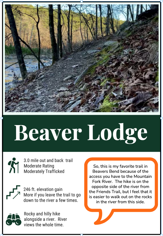
I just LOVE this trail! It has everything that I enjoy: hills, winding paths, forest views, and the constant sound of the river. This trail is on the opposite (west) side of the river from the Friends Trail, but the reason that I choose the Beaver Lodge Nature Trail over Friends Trail as my favorite is that there is better access to the Mountain Fork River from this shore. On the east side while walking the Friends Trail, you can go down to the river and even out on a couple of boulders to get closer to the waterfalls, but on the Beaver Lodge Nature Trail side, you can walk out into the middle of the river on large rocks and stones (definitely be careful and this may not be best for smaller children). I love being able to get close to the waterfalls and whitewater to take photos and to feel more connected to the flow of water.
I also find this trail to visually stimulating during any season. You can often see people fly fishing along the river while you hike, and it is a fairly good workout with all of the hills on the trail. I highly recommend this path - which is often overlooked because people choose the Friends Trail Loop instead. I typically prefer loop trails, but the scenery on this out and back trail is so good, it is worth seeing twice. Give the Beaver Lodge Nature Trail a try when you are in Beavers Bend and let me know what you think! I would love to hear about your favorite hikes in Beavers Bend and see your photos - Use the tag #pinesandcoastlines on social media.
Want the Best of Both Worlds?
The Spillway Loop Trail is a 4 mile loop that combines the Beaver Lodge Nature Trail (starting at the spillway) with part of the Friends Loop Trial and then continues back to the spillway. There is a 531 ft. elevation gain on the trail. Note that you will need to walk on the road at each end of the river to make the loop. Look at the map on AllTrails before you begin the trail.

Waterfall on the Mountain Fork River as viewed from the west side of the river from the Spillway Loop and Beaver Lodge Trails.
Other Things to Know Before Your Hike:
Parking: Here are a few other things to consider while hiking in Beavers Bend State Park. First of all, you will need to register your car for parking. The rangers check lots regularly, and you will pay twice as much if you get a ticket than if you just pay for parking. Go to the TravelOK site to easily register your car. You will need to pay for parking based on the number of days you will be in the park. You can also use this site to find lodging and camp sites in Beavers Bend.
Footwear: Broken Bow is a very rocky area. For any hike in Beavers Bend, close toed shoes are recommended. Wearing hiking boots is preferred. With hilly terrain and root-covered paths, it is easy to stub a toe or twist an ankle. Be mindful that there is loose shale along the Mountain Fork River below the spillway and the rocks also become very slippery when wet. Also, be aware when scrambling in rocky areas because snakes may be in the rocky areas.
Cell Service: I am typically able to get one or two bars of service when in the park, but I always download trail maps before I go hiking, and I let someone know where I will be if I am hiking solo. The AllTrails app is great for learning more about the hikes and finding downloadable maps for trails. Don’t count on having cell service, especially if you are hiking in lower areas of the park.

Mountain Fork River below the Friends Loop Trail and Beaver Lodge Trail.
I hope that you have found this to be informational. With Pines and Coastlines, I want to provide practical tips and travel inspirations for those who have a heart for wandering in nature. Please consider joining our Pines and Coastlines community by sharing your email via a form on our home page. You will receive content directly to your inbox, so you don’t miss out on the content that conveys a spirit of travel adventure.